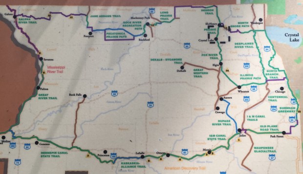
Whenever I come to visit my family in the Crystal Lake area I make sure to spend some time on the Prairie Trail and its connecting Fox River Trail. The Prairie Trail extends from the south edge of McHenry county at Algonquin Road north all the way to the Wisconsin border, a distance of 26 miles, all of which I have traversed at one time or another on foot, bicycle, or both. At the county line on the south the trail connects with Kane County’s Fox River Trail which extends another 40 miles south along the Fox River to Aurora and a bit beyond, as well as the Illinois Prairie Path that extends southeast to Wheaton. I have also traversed the first 30 miles of the Fox River Trail during various excursions in the area as well as a few miles of the Illinois Prairie Path.

During the last Ice Age northeastern Illinois as far south as Shelbyville was covered by ice, and as the glaciers retreated they left behind a lot of debris in the form of gravel and crushed rock. Those deposits of rock, gravel, and sand are called moraines and those moraines, along with flatter glacial outwash plains, are a dominating feature of the landscape in this area. On Sunday I took a short hike through the heart of one of those areas. The three mile stretch that I traveled began at the southern edge of Crystal Lake at Berkshire Road and about a mile in followed an old railroad right-of-way that ran along and through an area where rock, gravel, and sand are being extracted from one of those moraines.


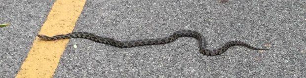
The second mile of this hike ran though McHenry County Forest Preserve land, and at points along the trail you can see some of the marshes that are common in this area and piles of railroad ties left over from the railroad tracks that once utilized this right of way. I have in the past seen deer, foxes, and other wildlife along the trail, but on this hike the only significant sighting was the garter snake below who had made to unfortunate choice to bask on the bike trail. As there was quite a lot of bike traffic on this beautiful Sunday I stopped and, ignoring his best attempts to imitate a rattlesnake by shaking his tail, managed to coax him off the trail before he was run over by approaching bicyclists.
The third mile of the trail is on an easement through property that is being actively quarried, and the screenshot from Google Earth below shows the area currently being excavated. Many of the recreational lakes in this area, like the Three Oaks Recreation Area, are former quarries that have been allowed to fill with water.

There are several miles of active conveyor belts in the area, and one of them parallels the Praire Trail for about a half-mile before dumping the output of the quarries into the sorting and sifting plant that marked the endpoint of this particular excursion.


The Prairie and Fox River trails are just two of the components of a very extensive trail system that spans most of Northern Illinois. As you can see from the map below, it is currently possible to travel on existing trails from Park Forest to Moline, almost the entire breadth of the state, with the exception of the Kaskaskia-Alliance segment (about 25 miles) that is still under development (in blue on the map). I look forward to the day when one will be able to make a complete circumnavigation of the northern portion of the state entirely on the dedicated trails (shown in green on the map).