
Long Beach is not the ideal place for me to live. I have found that the best exercise for me is walking uphill, and when I talk about walking uphill I’m referring to uphill stretches measured in miles, not meters, and those kind of hills just don’t exist in Long Beach. Now that my gait is pretty well straightened out, and my feet/knees/hips are getting back to being pretty reliable, I decided that it was time to do some trudging. I also am trying to avoid using my car, so I hopped on the Blue Line, transferred to the Red Line, and got off at Hollywood and Highland. The plan was to walk to the next station, at Universal/Studio City. It’s only 4 minutes by train, and a couple of miles as the crow flies, but also on the other side of the Hollywood Hills.

My route was to walk west on Hollywood to La Brea, north on La Brea to Franklin, west on Franklin to Fuller, and north on Fuller into Runyon Canyon Park. Runyon had been closed from April through July, but is now open again.


There are several routes to the top. When you enter the park from Fuller, if you continue straight ahead on the paved surface it will rise, and then double back up the east side of the canyon before reaching a relatively short but very steep section up the top of the ridge to the middle level of the canyon. In the picture below you can see where the paved road ends at the right before the steep section. There is a flat area with a good view at this point, and those who are exercise-challenged often just make it this far before heading back.
Road to the East Ridge trail
If you do go for the steep ascent up the east ridge you will come to another plateau with excellent views. This will also connect you with the main Runyon Canyon road as a descent option. Going down the steep section can be a challenge if one is physically or mentally challenged by very steep descents.

View from the middle plateau
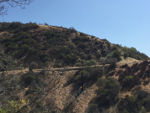
I took the unpaved but well traveled path that goes up to the left and leads up to the gate at Vista and the paved Runyon Canyon road. If one is feeling very energetic, there is an option to head off the road to the West Ridge trail. That trail is quite steep, quite long, and fits my definition of a good trudge, but I decided to take it a bit easier for my maiden trudge and stick to the road for this trip.

Runyon Canyon Road at bottom, West Ridge trail above


Runyon Canyon road meets Mulholland Drive, and I turned left on Mulholland and headed towards the intersection of Woodrow Wilson Drive and Mulholland. Woodrow Wilson intersects Mulholland in two locations, with the second intersection at Laurel Canyon Blvd. I lived for ten years (1992 – 2002) in a house at that intersection, and a couple of years ago I discovered the Harry Bosch series of police procedurals by Micheal Connelly and got hooked on them. The first one came out in 1992 when I moved to the hills, and Harry was a police detective living in a precariously cantilevered house on Woodrow Wilson Drive. In addition to providing a fascinating chronicle of how the work of detectives has evolved over the years with the advent of technology (in the first few novels they spend a lot of time looking for pay phones), it was very cool to see Harry traveling over areas very familiar to me. One of the objectives of this hike was to see the Harry Bosch house, if indeed it exists. According to Connelly, there was no real house, but when he was looking for locations he saw the foundation of a house that had been condemned and demolished and built up the house in his imagination. I did find that foundation at approximately 7203 Woodrow Wilson


Then it was on down the hill to Ventura Blvd, and a short hike to one of my old favorite haunts (and a favorite of Harry Bosch as well), Poquito Mas, for lunch.


The service area and the menu at the Mas has gone through a lot of changes, and I know that a lot of the old Poquito Mas crew will be disappointed by the missing menu items. It is still good, but not quite the same! After lunch was the short walk up Lankershim to the Metro station. The walk, with a couple of short side excursions, came to a total of 8.1 miles, with a total elevation gain of about a thousand feet. Just about perfect for right now!

One thought on “Urban Hiking, August 12, 2016”