
Well, it is now Thursday morning, 9 am. Up at 5 this morning, internet until 6, an hour of stretching and strengthening, a shower, walk 1.7 miles to Steelhead Coffee where I am greeted by Nick, Skyler, and Amelia behind the counter, have my usual cortado with egg’s and Manchego on toast prepared by the lovely Zoe (aka, @rosemarysbabyzoe), followed by ten minutes of folding, stretching, squatting, and balancing in the parking lot, and I am now ready to write.
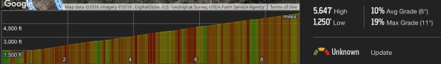
Elevation Profile for Mt Wilson Toll Road
This week has been a rather low mileage week, which is probably good since parts of my body have been complaining a bit about the stress put on them by Sunday’s trudge up the Mt. Wilson Toll Road. I have gone through several cycles in my life where circumstances, usually work-related and then complicated by relationship issues, cause me to not get sufficient exercise. When that happens, I can actually put on about a pound a week and before I know it I am 60 pounds overweight, with bad feet to boot. One of my most valued tools for reversing this trend is the trudge.

Ready to trudge!
A trudge is like a hike in that it involves walking in a natural (or more natural) setting on a natural (or more natural) surface. It is a special case of a hike, however, that requires a) non-technical walking on easy surfaces, and at least 3 miles (5K) of an unrelenting grind upwards that gains at least 1000 ft of altitude over that span.
The Mt. Wilson Toll Road is the ultimate trudge. It begins at the head of Eaton Canyon Regional Park, although the best access is off Pinecrest, in Altadena. From the gate the trail descends, crosses over the creek, and then begins an almost uninterrupted climb to the summit of Mt. Wilson. The distance is 10 miles, and there is about 4400 feet of altitude gain. I like it for training as I can hike up until I have had enough (keeping in mind that I will also be descending, which I like much less than ascending), and then turn around. When I get to the point where I can do the whole enchilada, then I consider myself up to snuff!


My destination for Sunday was the first real landing pad on the hike, Henninger Flats. Henninger Flats is the first (and perhaps only) place where the road levels off, and it sports a campground, picnic area, and restroom facilities (although the modern facilities were locked and only the rustic ones were available). It is about 3 miles from the gate to Henninger Flats, and there are 1325 feet of elevation change involved.


On Sunday I started my trudge at about 10:30 am, hung out at the Flats for a little while, headed back down, and returned to my car at 2 pm. Only some relatively minor complaints from my left hip and my right foot, and I was energetic enough to head out to Calabasas to visit one of my families, the Dennis’s–I was feeling guilty because I had stood up the Dennis’s on Thanksgiving, opting instead to head down to La Jolla to visit yet another of my families, the Feifer’s. Need to keep ones families happy!
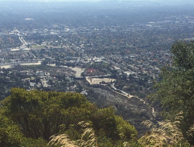
Eaton Canyon drainage from Henninger Flats
My current goal is to do a trudge each Sunday. In addition to the Toll Road, which I am planning on doing on the first Sunday of each month as a benchmark, I have a good trudge up the North Ridge Trail in Chino Hills State Park. That trail has been officially closed for a couple of years, but I am guessing that I can still get past the closure for the ascent, and by connecting to the Sycamore Trail it can be turned into a loop where the descent is a bit more forgiving.
